SOTA in Vermont: Blue Ridge Mountain, W1/GM-033 and Ludlow Mountain, W1/GM-037, May, 2015

Our last SOTA visit to Vermont was in October of 2014; the trees had changed color and were losing their leaves and it was cool enough to require hats and mitts.

Fast forward to May 2015. The trees are in leaf, the sun is shining and summer is just round the corner. Shorts and t-shirts… not so fast. This is VT, and the morning we planned to go up Blue Ridge Mountain it was below freezing when we got up, and we were discussing whether we had enough layers or whether we needed a quick stop at EMS for more thermal underwear!

Blue Ridge Mountain (3278 ft / 999 m) is close to Killington and Pico ski areas, with easy access from Old Turnpike Rd., off Rt. 4, above Rutland. The Canty Trail used to start at a gated dirt road, but now the trail head has been relocated a few hundred yards further up Old Turnpike Rd., with a small roadside parking area for a few vehicles. The trail is generally very clear, well marked with blue blazes, and is well-maintained. The first half-mile or so is up and down through woods, then the trail crosses a stream, and shortly afterwards arrives at an old farm road which starts a steady climb. Following this upwards, always fairly close to the stream, the road ascends gently for another half mile or so, but then transforms into an increasingly steep and rocky trail. In places you can easily drop down to the stream to see the falls and pools.

Long exposure of cascade on mountain stream

Cascade, Canty Trail

As the route heads away from the stream, the steepest section of trail gives way to a sustained but more moderate climb, with the trees changing to predominantly conifers near the top. There is a small, rocky summit, with views to the south east. A short spur trail leads to an opening in the woods just below the summit, overlooking Rutland. The total ascent is about 1500 ft, and the hike to the top took us about two hours.

The radio equipment for this activation was my usual SOTA setup, KX3, with a 33 foot vertical supported by a DX Wire fiberglass pole, fed at the base with a switchable 1:1 or 1:4 unun. The pole was pushed up through some of the stunted trees at summit, easily reaching above the highest branches. The summit rocks provided a comfortable enough spot to set up. Conditions were not great, but still made 32 HF QSOs (24 NA, 8 EU)  over an hour of operation. One was a 15 m CW summit-to-summit contact with N1FJ, on Mt. Ascutney, in SE VT; guess this was line of sight propagation, not involving too many bounces off the ionosphere. Tried calling on 2 m, but no responses.

As far as I know, this was the first SOTA activation of Blue Ridge Mountain.

Vertical antenna on the summit of W1/GM-033

Vertical antenna on the summit of W1/GM-033

The following day, we took the easy option, driving Mountain Road most of the way up Ludlow Mountain W1/GM-037. This is the ski resort of Okemo, and in the winter the road forms one of the easier trails down the mountain. Parking at the gated end of the road, it’s a short climb up to the summit where a fire tower gives a fantastic view above the trees. It was quite windy, and I really felt exposed up on the tower. Coming back down, we walked into the woods a short distance from the fire tower and set up the station among the trees. Again, leaning the pole against branch avoided having to put out any guys to keep the antenna up – in contrast to the winds up the fire tower, it was calm in the woods. We had hiked elsewhere in the morning, so it was mid-afternoon by the time we got to W1/GM-037 and by then propagation conditions were not great, so after a relatively short activation (22 contacts), it was time to go back down the hill.

K3EL operating from Ludlow Mountain, W1/GM-037

K3EL operating from Ludlow Mountain, W1/GM-037

My usual specialty is grungy one-pointers in NJ, so grabbing four points for Blue Ridge Mountain and six for Ludlow was a novel experience (especially since Ludlow didn’t involve much climbing). Blue Ridge Mountain is 999 m high, so it just misses out by 1 m from being a six-pointer. Maybe if we start building a cairn and all leave a rock on the top, it could get upgraded in a year or two?

SOTA Bald Mountain W1/GM-167, 12th October 2014

My XYL and I have been visiting the Green Mountains for years, but it’s only recently that we’ve come to SOTA, hence I didn’t realize how many of the W1/GM summits have never been activated. If the numbers on SOTAwatch are accurate, less than 50 of the 253 GM summits have been SOTA’d! Having had a fine time at Antone Mountain on Saturday, what could we do on Sunday? Well, with all those summits begging for an activation, more SOTA, of course! There are probably access issues for many peaks which explains why they haven’t been activated, but after a little consultation with SOTA maps, the adventure radio maps and the Green Mountain Club’s “Day Hiker’s Guide to Vermont” we found a few unactivated SOTA summits with good trails. Bald Mountain was chosen as the day’s target. Now comes the “mea culpa” – during the activation I was giving out W1/GM-055 as the summit reference. That is a Bald Mountain, about 10 miles south-west of Rutland, but its not the Bald Mountain which we activated, (W1/GM-167) in the Aitken State Forest, a couple of miles to the east of Rutland. Apologies to all chasers for the confusion caused. Just to add to the potential for mix-ups, there are another two SOTA summits named Bald Mountain and one Bald Hill in the W1/GM area, as well as many other Balds which don’t count for SOTA. Bald Mountain W1/GM-167 is not particularly aptly-named, since although there are a couple of excellent viewpoints the summit is mostly well-wooded, and not bald at all. Perhaps it was balder back in the day?

The start of the Bald Mountain trail.

The start of the Bald Mountain trail.

Bald Mountain is a relatively low summit (2090 feet) on a chain of hills just to the east of Rutland which separate the Otter Creek valley from the higher Green Mountain peaks of Killington and Pico. There is a loop trail which traverses the north and south summits of Bald Mountain, offering shorter or longer loop options (map). The trail is clearly signed at junctions, and there are fading blue paint blazes along the way (less faded in one direction than the other – perhaps they didn’t tell the last lad they sent up the hill with the pot of paint to color both sides of the trees?). There’s a short connecting section of trail from the road to the start of the loop, with sections of puncheon and boulders to step across – looks like it can get wet at times. After about 10 min, there’s an obvious fork in the trail with a big sign to indicate the beginning of the loop. We took the circuit clockwise, the most direct route to the higher northern summit. From this point, it’s a moderately steep trail, easy to follow, through an open hardwood forest.There are several viewpoints along the loop, offering vistas of the central Green Mountains, of the valley, and of Rutland.

OLYMPUS DIGITAL CAMERA

K3EL at one of the clearings offering a view of Pico Peak.

OLYMPUS DIGITAL CAMERA

Fiberglass mast propped up between the tree branches.

One of the viewpoints is near the summit. Close by is an enticing boulder offering comfortable seating to operate from, and thus our site was chosen. Equipment was the same as for Saturday’s activation of Antone Mountain. Once more, the trees provided a convenient support for the pole, and so we were able to dispense with guy ropes. At the summit the trees are quite low, and so the antenna mast protruded well above the topmost branches. There was a good Verizon cell signal at this site, so easy to see if you’re spotted on SOTAwatch – it was impressive to see how quickly an RBN spot appeared after calling CQ.


OLYMPUS DIGITAL CAMERA

The operating rock, Bald Mt.

Once the radio was set up, we donned our extra layers. The temperature was only in the 40s and we expected to be sat around for an hour or more – having hauled the radio gear up the hill, I don’t want to just have the minimum four QSOs to make an “official” activation, I want to stay long enough to make a QSO with anyone who wants one. First QSO was with DL6AP at 1542, and both 17 m and 15 m were hopping, with about 2/3 of the contacts with EU. After that, it was time for lunch. 40 m then provided some more local Qs, then up to 20 before finishing up on 15 m, last contact being with I6FPN at 1709. Out of 62 contacts, 25 were with North America, the rest with EU. This was a record number of contacts for one of my SOTA activations, and we also had bight sunshine, a good flat rock for a seat, and a view of the mountains from our summit location. What more could you ask for?

Fungi at the base of the trail.

Fungi at the base of the trail.

Bald Mt. was a pretty busy summit. We arrived around 10 am, at which time the parking spaces across from the gate to the trail were empty. When we returned mid-afternoon there were several cars, and we met quite a few walkers during the day. One commented that “it’s only locals that come up here”, he was clearly surprised to find two tourists from NJ on his mountain. We didn’t meet much wildlife. Perhaps all the activity on the trail scared them off. Lots of attractive mushrooms near the bottom of the trail, though.

Thanks to all the “chasers”, who make SOTA such an entertaining activity!

SOTA Antone Mountain, VT W1/GM-199, 11th Oct 2014

We made a last-minute decision on Thursday evening to go see the fall foliage in VT at the weekend. That sent me chasing off to the SOTAwatch website to see whether we could combine leaf-peeping with some SOTA. Looking at the listing of W1/GM summits, it wasn’t surprising to see that the major ski peaks had multiple activations listed. However, I immediately recognized several hills we’d hiked in years past which were SOTA summits, including several which had no record of SOTA activation.

Antone Mountain is a 2600-foot peak in southern Vermont which I first visited in 2000 and have been back to since. It’s in a large tract of preserved land managed by the Merck Forest and Farmland Center, an educational nonprofit organization. The higher elevations were once farmed, but have long-since reverted to forest. However, some of the old farm tracks still head up into the hills and now form part of a network of hiking trails which include an easy route to the top of Antone Mountain. The distance from the visitor center parking to the top of the hill is about 2.5 miles with around 900 feet of elevation gain.

The top of Antone Mountain peaks above a ridge. A slight gap in the trees on the summit marks the viewpoint.

The top of Antone Mountain peaks above a ridge, as seen from the farm. A slight gap in the trees on the summit is the viewpoint.

The trail is broad, fairly smooth, and generally not too steep if you stick to the Antone Mountain Road. We varied things a little this time, ascending via the Ski Trail and returning via the McCormick Trail. There are zero route-finding issues, an excellent map is available at the visitor center and all the trails are very clearly signed. The whole area is very popular with day hikers and families so expect to have plenty of company. Antone is the highest point in the Merck Forest lands and has a great lookout at the top, so it’s one of the most popular destinations within this preserve.

View of the farm from the top of Antone Mountain.

View of the farm from the top of Antone Mountain.

Mid-October is peak leaf season, and this year the fall colors were quite impressive throughout the parts of mid and southern VT which we visited. When we arrived at the parking it was around 40 F and cloudy. We’d brought plenty of clothing to keep warm whilst SOTAing, so our daypacks were pretty full. The hike up via the Old Town Road and Ski Trail took around 90 min. The lookout at the top of Antone Mt. allows a fine view of the farm which you walked past on the way up. We picked a spot to set up near the trail just beyond the lookout, a few yards away from the trail itself. The antenna used was a 33 foot vertical; since there are many low trees on the summit, we didn’t bother guying the DXwire pole, just telescoped it up through the branches and let it rest there. The antenna wire was fed through the center of the pole, and exits the pole near the base via a small hole drilled in the side of the bottom section. We laid out a dozen radials of varying lengths (12 – 33 feet) and connected the coax to the antenna via a switchable direct feed (on 40/15, bands where it’s resonant) or a 4:1 unun (20/17/15). Rest of the gear included a KX3 with Begali Adventure paddles, and a piglet and iPad running the hamlog app for logging. Power was from a LiFePO4 battery.

KX3 in action.

KX3 in action.

I started calling CQ on 17 m around 1530 UTC. There’s marginal or no cell coverage on the summit so I couldn’t send an alert, but after a few moments it was clear I’d been spotted because there was a flurry of calls. Ten QSOs later things slowed down; there was QRM on 18.085, turns out a W1AW station was getting busy 1 kHz below, and the pile was spreading out. No problem, let’s try 15 m. Once more, good conditions, with QSOs into the central and western US, and across the pond. After 15 m was tapped out, up to 40 m for some more local QSOs. A few CQs on 146.520 produced no response. While I was operating my XYL explained to curious passing hikers what we were doing, what is ham radio, what’s a SOTA, etc. Then off to 20 m; a few calls, but relatively slow going, so back again to 17 m. The first contact of this session was with UR5UID, the best DX of the day. We finally figured it was time to pack up and go around 1700 UTC; W7USA was the 46th and last contact in the log from this first activation of S1/GM-199. 16 Qs were with EU stations, the rest from the USA. Timing was good, because just as we finished up a large group arrived at the summit.

Hickory tussock moth caterpillar.

Hickory tussock moth caterpillar – luckily we didn’t touch, these fellas can give rise to a nasty reaction like poison ivy.

Down by the farm, there were lots of woolly bear caterpillars crossing the Old Town Road, going from west to east. Apparently there’s a woolly bear caterpillar myth which relates the severity of the coming winter to whether the caterpillars are going north or south… unfortunately these fellas were going west to east, so no predictions for the winter of 14/15. At the top of the mountain, this caterpillar was sat on a fern near to the operating position – didn’t realize, but it turns out they’re not good to touch since they can cause a nasty rash, like after exposure to poison ivy.

All in all, a very pleasant hike, and a productive SOTA activation. We topped the trip off by purchasing a gallon of maple syrup made on the farm at the Merck Forest preserve.

SOTA Stonetown High Point (Windbeam Mountain), W2/NJ-012 – 5th Oct 2014

NJ doesn’t have a lot of SOTA summits – 12, to be exact. NJ-012 is Stonetown High Point (better known as Windbeam Mountain), a summit which I activated in 2013. It’s a steep hike, but a very pretty one. A fire burned here a few years ago, so much of the hike is through an open, regenerating forest with better views than the typical NJ hill. Because it’s a pleasant hike, we (my XYL and I) decided to go up there again this year. The weather was beautiful on Sunday, 28th September, and we arrived at the trail head around 9.30. Instead of parking near the playing fields on Mary Roth Drive, we stopped at a small roadside parking spot on Westbrook Rd., about 200 yds south of the junction with Stonetown Rd. The trail head is on the north side of the three-way junction. This makes for a significantly shorter hike than if you park at Mary Roth Drive, since you avoid the lengthy (but interesting) walk through a boulder field which parallels Stonetown Rd.

The fire tower which used to sit atop Windbeam Mt. http://www.firetower.org/lookouts/Lookout.aspx?id=1560

The fire tower which used to sit atop Windbeam Mt. http://www.firetower.org/lookouts/Lookout.aspx?id=1560

It was surprisingly warm, with the temperatures close to 90 in the afternoon. Still, we huffed and puffed our way up to the top. It was easy to find the same spot which we’d used to activate W2/NJ-012 last year, but we continued further north along the ridge to the very highest point of the hill, and set up on a rock outcrop about 100 feet to the east of the trail just where the ground starts sloping down. At this point the top of the ridge is quite flat, but only a couple of hundred feet wide. Close by are the remains of the concrete footers for the old Windbeam Mt. fire tower, constructed in 1920. The tower was moved in 1971, and is now located on Ramapo Mountain, a few miles away.

We erected a DXwire fiberglass “mini” mast to support a 33′ vertical, laid out the radials, set up the radio… and discovered that the powerpole to coaxial DC connector was nowhere to be found. We had a battery and a KX3, but no way to connect them! Much cussing didn’t help any electrons excite the radio, and so back down the hill we went. Consolation was sought at the ice-cream store in Wanaque, but we were too early, they didn’t open until 2 pm. The disaster was complete, and we returned to Princeton, hot, tired and without any QSOs.

Being of an ornery nature, plans were made to return the following weekend. Lesson learned, this time a more thorough inventory of equipment would be made when packing gear (coincidentally, a “perfect checklist” was just posted to the files section of the Yahoo SOTA group!). Sunday, 5th Oct. was forecast to be sunny but cold, and we arrived at the same parking spot at 8.45 am with the temperature hovering around 40 F rather than 80 F the week before. Gloves and woolen hats would have been welcome! The ground was well-covered with fallen leaves, occasionally making the path hard to discern, but there are good blazes in the trees. Anyway, we could remember the way from last week’s ascent… It took us a little over an hour to get from the trail head to the top of Windbeam Mt. There are good viewpoints at various spots on the way up – look out for the skyscrapers of Manhattan peaking over a ridge when you’re atop Little Windbeam.

Setup was the same as the previous week, with the vertical placed atop a rock outcrop, and a dozen radials draped over the ground. The 33 ft vertical was fed via a switchable direct feed (for 40 and 15 m) or a 4:1 unun (to tame the mismatch on the other bands), with 12 feet of RG8X coax to the KX3. This is a lighter setup compared to the base tuner which I’ve used previously, and seemed to work very well.

Operating from W2/NJ-012

Operating from W2/NJ-012

A CQ on 17 m CW quickly produced a caller from HB9, followed by EA and ON as well as several Stateside QSOs.

KX3 and a piglet, with hamlog for logging.

KX3 and a piglet, with hamlog for logging.

20 m produced another dozen or so contacts, 40 m not so many. 15 m was good for another dozen, with half being to EU including some very strong signals from Scandinavia, then back to 17 m to finish off the afternoon. Out of 46 QSOs, 13 were with EU stations, and nearly half of the RBN spots for this operation were from EU. Clearly conditions were good for DX, particularly on 15 and 17.

We saw our fair share of wildlife on these two trips up Windbeam Mt. On the first we met a black rat snake, some five or six feet long. On the second, we found this turtle close to the base of the old fire tower.There weren’t many fellow hikers on the trail, we saw about half a dozen each day.

Eastern box turtle on Windbeam Mountain

Eastern box turtle on Windbeam Mountain


SOTA Stonetown High Point (Windbeam Mountain), W2/NJ-012

Windbeam Mountain (listed in SOTA as the Stonetown High Point, W2/NJ-012) is a peak in northern NJ, overlooking the Wanaque reservoir. This was the choice for my xyl and I for a hike and some radio on the Saturday of the 2013 NA SOTA weekend.

There’s a clearly-marked trail which leaves from close to the large parking area on Mary Roth Drive. The trail is indicated on the NY-NJ trail association map 115. After crossing the Stonetown Road, the trail heads into an occasionally-boggy boulder field at the foot of Little Windbeam. The trail is well-marked with red triangles. compressed-0499To begin with it deviates from the trail indicated on map 115, running closer to the road and along the flat rather than cutting across the hillside. Eventually, it turns left and starts climbing, intersecting the NJ Highlands trail, after which the red triangles are joined by blue diamonds. Then it’s a steep, rocky hike up Little Windbeam. The trail is partly wooded but there are quite a few open areas, both where the forest had burned years ago, as well as some large rock outcrops. Consequently, there are some good views from the top.

View from Little Windbeam.

View from Little Windbeam.

There’s still a bit of a walk after Little Windbeam, with a series of short descents followed by ascents to subsidiary peaks, before arriving at the relatively flat top of Windbeam Mountain. We were puffing a bit at times on the way up (too much fine dining, not enough fine hiking). However, the description of Windbeam on the NJ1K website made us feel a little less guilty: “At only 1040′, Windbeam is the fifth lowest mountain on our NJ1K list, but Windbeam actually takes more vertical climbing to summit than nearly any other mountain in New Jersey… The Highlands trail’s ascent up Windbeam from the south is one of the longest sustained steeps in New Jersey”. Ok, so that’s not saying much, but it helped dissipate some of the negative vibes from our rather slow ascent.

The top of Windbeam is very pleasant, a small plateau with open woods, and the occasional rock outcrop providing a somewhat comfortable operating position.

compressed-0467

K3EL operating from W2/NJ-012. KX3 and an iPad with hamlog and a piglet.

For my last couple of SOTA trips I’d taken a 31-foot vertical with a Z11-pro tuner used at the base. Although it seemed to work reasonably well, this isn’t a particularly lightweight setup. So this time I tried something different, a 54-foot inverted vee dipole fed with 300 ohm ribbon. This was connected to the KX3 via a few inches of coax and a 4:1 balun. The pole was set up on a rock outcrop, on the NE side of the summit. The ground in the immediate vicinity of the antenna was pretty flat, but within 100 yards or so it started dropping away. Looked like it should be a promising site, and the morning started off well-enough with a decent little pileup on 20 m. However, there were few callers from EU all day. Given that conditions seemed ok (indeed, bands were hopping when I got home in the evening), the lack of DX was a bit disappointing, and this prompted some comparison with my last two SOTA trips where the vertical was used.

date antenna SFI SSN A-index # qsos # EU # RBN # RBN EU
9th June 31′ vert 96 41 9 46 8 45 6
11th Aug 31′ vert 110 90 6 41 7 72 19
7th Sept 54′ dipole 99 35 4 45 5 55 0

SFI = solar flux; SSN = sunspot number; #EU = number of EU QSOS; #RBN = total number of RBN spots; #RBN EU = number of RBN spots from EU.

On each trip, bands used were mostly 40, 20 and 17. Looking at the number of EU qsos, it doesn’t seem too different between the various operations. However, this time, I’d mixed CQing with an effort to actively hunt out DX summit-to-summit qsos, whilst on the two earlier trips I’d just been CQing. The RBN results are perhaps more telling; zero EU spots this time! Puzzling, since you wouldn’t expect a huge difference between the two antennas. I’ve previously made A/B comparisons in my garden between the 31-foot vertical and the inv-vee (apex at about 27 feet). Switching between them resulted in a very similar or slightly better performance off the sides of the dipole on 30/20/17, whilst the vertical was better for signals coming from the direction of the ends of the dipole – all pretty much as expected. So, were conditions just not as good as expected this weekend, or what? Thinking about it some more, perhaps the dipole was compromised by the way it was put up on the hilltop. The wires got caught up in low tree branches, which bent the top of the pole down sharply, and forced the top of the dipole elements together. Modeling the resulting configurations in EZNEC, you get the following. First, the inv vee configured as in the back garden, apex at 27 feet, ends about 12 feet up:

SOTA inv vee 27 foot apexNext, a configuration similar to that on the hilltop, with the feed point at 22 feet, with a sharply pointed apex to the vee, and then the lower part of the wires gently sloping and closer to the ground:

SOTA inv vee 22 foot apex squashed

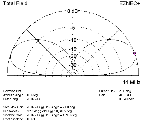
The radiation pattern has shifted upwards. Not so good for DX. Finally, here’s the 31-foot vertical. All antennas were modeled over average ground. The vertical has 30 ohms load resistance to ground, to mimic significant ground losses.

SOTA 31 foot vert

So although the peak gain for the half-wave vertical is lower than for the dipoles, the gain at useful DX radiation angles is competitive, especially when compared to the the compromised vee configuration. Sure, band conditions probably had a lot to do with the results from atop Windbeam Mt., but still, next time I’ll pay a bit more attention to how the dipole is actually strung up!